The Battle of Klingle Road
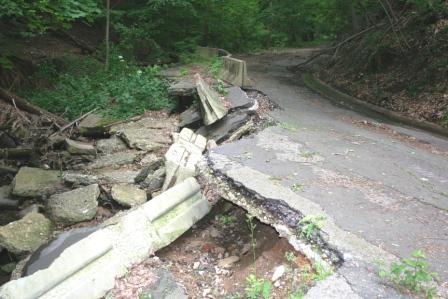
In 1991, a three-quarter-mile segment of Klingle
Road, just west of Rock Creek Park, was washed out by stormwater, and the road
closed to traffic. That event triggered a bitter battle that has gone on for
years, with extraordinary intensity. It appears to be approaching a conclusion,
in 2008, 17 years after the closing of the road. We'll see. But here, as briefly
as I can do it, is the story, and why it has been such a battle.
East-of-the-Park lifestyles
 For years after the 1968
Martin Luther King riots, all of DC east of Rock Creek Park was in decline and not
very desirable. Mount Pleasant for some years consisted
of inexpensive rooming houses. In time, the residential areas closest to the
Park began to recover, middle-class people (like yours truly) buying houses in
Mount Pleasant and Crestwood. But this recovery extended only a few blocks to
the east of the Park. Columbia Heights remained, for years, a rough
neighborhood, with some of the highest crime rates in the District. Schools were
poor, and shops catered to a low-income clientele. Residents looking for better
shops and schools quite naturally zipped across the Park to the wealthier
neighborhoods to our west, Cleveland Park, Woodley Park, Tenleytown, Georgetown,
et cetera. Even Mayor Marion Barry, a prototypical urban-black politician, sent
his children to Murch Elementary, west of Rock Creek Park (all the way from
Southeast DC). For us residents of Mount Pleasant and Crestwood, our homes were
east of the Park, but our shops, restaurants, and schools were west of the Park.
For years after the 1968
Martin Luther King riots, all of DC east of Rock Creek Park was in decline and not
very desirable. Mount Pleasant for some years consisted
of inexpensive rooming houses. In time, the residential areas closest to the
Park began to recover, middle-class people (like yours truly) buying houses in
Mount Pleasant and Crestwood. But this recovery extended only a few blocks to
the east of the Park. Columbia Heights remained, for years, a rough
neighborhood, with some of the highest crime rates in the District. Schools were
poor, and shops catered to a low-income clientele. Residents looking for better
shops and schools quite naturally zipped across the Park to the wealthier
neighborhoods to our west, Cleveland Park, Woodley Park, Tenleytown, Georgetown,
et cetera. Even Mayor Marion Barry, a prototypical urban-black politician, sent
his children to Murch Elementary, west of Rock Creek Park (all the way from
Southeast DC). For us residents of Mount Pleasant and Crestwood, our homes were
east of the Park, but our shops, restaurants, and schools were west of the Park.
That placed a premium on travel from east to west,
especially in the morning, when rushing one's children to school, then hurrying
off to work. Here in Mount Pleasant, there was a heavy rush every morning of
cars heading west, to those "better" west-of-the-Park schools, such as Murch and
Eaton. Few professional-class residents of Mount Pleasant were willing to send
their children to our neighborhood school, Bancroft. (As of 2003, Bancroft was
just 2% white non-Hispanic, in a neighborhood that was at least 35% white
non-Hispanic.)
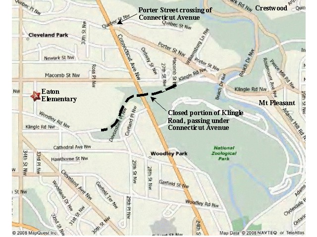
This is where Klingle Road was such a great
convenience. The map shows how one gets from Mount Pleasant, on the far right,
to Eaton Elementary, the starred location on the left. Klingle Road was a nicely
direct, virtually traffic-free route. The alternative route is on Porter
Street (Klingle undetectably becoming Porter, as "real" Klingle turns off just
west of the Park). The Porter crossing of Connecticut Avenue is notorious for
its congestion and long traffic delays. As is invariably the case in the
District, the north-south "commuter" routes are given favorable green-light
times at these intersections, while the east-west traffic waits. Hence, the time
difference for the Porter Street route, versus Klingle, can easily be 5 or 10
minutes.
 Thus, the abrupt
closing of Klingle in 1991 was upsetting to many residents of Mount Pleasant and
Crestwood. Drivers stuck in traffic at the Porter Street crossing of Connecticut
longed for the return of their quick and convenient Klingle route.
Thus, the abrupt
closing of Klingle in 1991 was upsetting to many residents of Mount Pleasant and
Crestwood. Drivers stuck in traffic at the Porter Street crossing of Connecticut
longed for the return of their quick and convenient Klingle route.
The battles begin
OK, so, why wasn't the road simply rebuilt, right
away? I know that the District Department of Transportation (DDOT) was reluctant
to put more money into repairs for this troublesome road, afflicted with
underground springs and torrents of water during summer rainstorms. According to
a City Paper report in 2000, "City officials were sick of paying to repair it".
The Klingle Road Draft Environmental Impact Statement (DEIS) says this: "As the watershed became more urbanized and
developed, stormwater loads increased to levels that began to cause excessive
erosion in Klingle Valley and irreversible damage to Klingle Road prompting the
road's closure." That is, it was the paving and buildup in the area that led to
increasing maintenance difficulty on this valley road.
There are
further reasons against the rebuilding of the road. For one thing, the residents
of Woodley Park, on the west end of Klingle Road, were not unhappy to have the
road closed. Like everyone else in the District, they want to be able to drive
easily to whereever they want to go, but they don't want any traffic on the
roads in front of their own houses. Klingle Road emerges on Woodley Road, a
residential street, so residents in that high-income neighborhood were treated
to little rush hours of Klingle Road commuters every morning. (Some residents of
Mount Pleasant want our "minor arterial" streets converted to "local traffic
only" residential streets, preventing drivers from passing through the
neighborhood on their east-west routes. These same residents want Klingle Road
opened, failing to perceive the irony in their willingness to impose on Woodley
Park precisely that traffic that they object to in Mount Pleasant.)
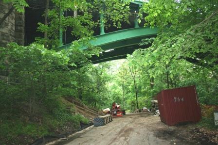
 But the crucial fact that makes Klingle Road different
from other such traffic-NIMBY situations is that it is in Rock Creek National
Park. More than that, it's in an exceptionally beautiful part of the park, a
deep valley of dense woods, and Klingle Creek at the bottom. The city was given
a 50-foot right-of-way for the "highway" in 1885, five years before Rock Creek
National Park was established. At the time, it was a gravel road descending to a
ford across Rock Creek. (Today, road advocates leap upon that "highway"
designation as justification for the reconstruction of the road. But no one in
1885 imagined fleets of SUVs on a hard-paved surface. Their "highway" carried
horse-drawn wagons down to the streambed, where the horses waded across the
creek.)
But the crucial fact that makes Klingle Road different
from other such traffic-NIMBY situations is that it is in Rock Creek National
Park. More than that, it's in an exceptionally beautiful part of the park, a
deep valley of dense woods, and Klingle Creek at the bottom. The city was given
a 50-foot right-of-way for the "highway" in 1885, five years before Rock Creek
National Park was established. At the time, it was a gravel road descending to a
ford across Rock Creek. (Today, road advocates leap upon that "highway"
designation as justification for the reconstruction of the road. But no one in
1885 imagined fleets of SUVs on a hard-paved surface. Their "highway" carried
horse-drawn wagons down to the streambed, where the horses waded across the
creek.)
The Park was already suffering for having become a heavy-traffic
commuter route in 1966, upon the opening of the tunnel connecting Beach Drive to
Rock Creek Parkway. A phenomenal 25,000 vehicles per day now use Beach Drive
through the tunnel, and these automobile drivers aren't there to enjoy the park scenery. The
National Park has become little more than a host for a freeway. Park
management has become resigned to this unpleasant use of their park on
Beach Drive, but isn't happy about it, and is considering methods of reducing the
commuter traffic burden. When Klingle Road, another busy commuter route through
parkland, was closed, the management of Rock Creek National Park was content to
leave it closed, preferring quiet parkland to a traffic-laden road.
That's a lot of arguments against the rebuilding of the road, but
the east-side residents who wanted their quick route to the west were
unpersuaded, and have been relentless in demanding the return of their road.
Leading the charge to reopen the road was Mount Pleasant resident Laurie
Collins, who built a Web site, Repair Klingle
Road, just for this purpose, and who put unrelenting pressure on
politicians for the return of the road, even as the years passed. Leading the opposition
to the road was an ad hoc group, the Klingle Valley Park
Association , supported by the DC Chapter of the Sierra Club.
The Berger Study
The District seems to have taken a "hope it goes away" approach to the issue,
perhaps thinking that if nothing was done, and the road remained closed, the
advocates would lose interest and move on to other matters. But they
underestimated the intensity of the road advocates. Green "Repair Klingle Road"
popped up all over Mount Pleasant. Laurie Collins created her Web site, and made
her Mount Pleasant Neighborhood Alliance a
loud voice for reopening the road. Collins raised money and organized
meet-and-greet gatherings for politicians who favored the road, and made
reopening the road a "litmus test" for any candidate. Ward One Councilmember Jim
Graham became a proponent of the road, and received Collins' fund-raising
support (as did Fenty, in his campaign for Mayor in 2006). At-large
Councilmember Phil Mendelson did not support the road, and found himself under
steady attack by Collins and her allies.
The pro-road forces were so vocal and demanding that the District was driven to undertake in 1999 a
detailed study
of the road, and the various alternatives proposed for it:
?
Option A: No Action -- do nothing, a choice mandated for
such studies
?
Option B: No Build -- repair retaining walls, rebuild
drainage
?
Option C: Green Space -- as B, but remove the roadbed,
allowing the area "to return to a natural state"
?
Option D: Bicycle, Recreation and Facility Management --
as C, but repave the road as a bike path (capable of supporting utility trucks
for servicing)
?
Option E: Rebuild Klingle Road to its Original Alignment
-- rebuild the road, as it was before
?
Option F: Build Klingle Road to Accommodate Vehicular,
Pedestrian and Bicycle Uses -- widen the road, for a two-lane road plus
bike/hike path
?
Option G: Build Klingle Road as a One-Lane (One-Way) Road
with a Pedestrian/Bicycle Lane -- one lane for cars, one lane for bicyclists and
pedestrians
Options A, B, and C were simply nonstarters. Option D had the
support of the Sierra Club, and Washington bicyclist organizations. Option E is
what the "Repair Klingle Road" people wanted. Option F was ruled out by the
narrow right-of-way possessed by the District through the National Park. Option
G was a fair compromise, but the road advocates refused to settle for anything
less than the full return of their road, for cars only, two-way, all the time.
Because the road is narrow -- the 50-foot right-of-way does not allow even for
shoulders, much less any adjacent sidewalk or bike path -- Option E would render
the road nearly unusable by bicyclists and pedestrians (similar to the situation
on Park Road, east of Beach Drive). As was the case before the closing of the
road in 1991, Klingle Road could be used in safety only by automobile drivers.
Perhaps that is why this was such a bitter battle; the only acceptable outcomes
were everything for cars, nothing for bicyclists and pedestrians on the one
hand, and nothing for cars, everything for bicyclists and pedestrians, on the
other. There was no middle ground.
The Berger study, released in 2001, resolved nothing. Traffic benefits of the road were found to be
modest: ". . . any reopening of Klingle Road would lead to significant delay reduction�
on Porter Street and moderate delay reduction on Cleveland Avenue
and Garfield Street. However, most of the already failed approaches at the study
intersections will continue to operate with an unacceptable level of service."
In short, all the benefit of the road accrues to the drivers who could use it,
instead of Porter Street, to reach their destinations.
Road advocates
wanted their road, despite its high cost, and the Berger study conclusion that
the road would yield little benefit to traffic flows elsewhere in the area. Road
opponents wanted the bike/hike/recreation option, no cars. The arguments flew
back and forth, persuading no one.
Among the perverse uses of the Berger
report was an absurd analysis of traffic
delays by the MCV Associates, claiming enormous traffic benefits on other
roads if Klingle Road should be reopened, despite the clear conclusion of the
Report. This claim was utter nonsense, even fraudulent, as I showed, and as any competent
traffic engineer would see. My conclusion: "Consequently the time
savings predicted for Porter Street eastbound is not credible. Since that is the
bulk of the overall time savings predicted, the total time savings is also not
credible. Consequently the MCVcalculations, which hinge on this calculation of
time savings, are not valid." This bogus traffic analysis was commissioned by
Peter McGee, husband of Laurie Collins, and equally vociferous advocate of
rebuilding Klingle Road. The Collins-McGee pair were aggressive in making such
claims, eliciting this
response by DDOT to Councilmember Mendelson.
The District Council acts
Early in 2003, the District Government took up the Klingle Road
issue again, now with the Berger study in hand. Mayor Williams
declared his opposition to the road,
summarizing the arguments against it: high cost, small benefits. The District
Council was unpersuaded, and inserted a line item in the District budget bill
(thus immune to veto), the "Klingle Road Restoration Act of 2003", requiring the restoration
of the automobile road:
"Sec. 2402. The portion of Klingle Road, N.W., between Porter Street,
N.W., on the east to Cortland Place, N.W., on the west shall be re-opened to the
public for motor vehicle traffic, with the repair and reconstruction of Klingle
Road, which shall include the establishment of a District Department of
Transportation storm water management plan, to commence no later than 180 days
following the effective date of this title."
Enacted in June, 2003, and becoming law in November, 2003 (after
the Congressional review period required for all District laws), the road
advocates considered their victory complete. The District prepared an
implementation schedule, planning for
road construction to begin in 2006, and the road to be reopened to traffic
in 2007.
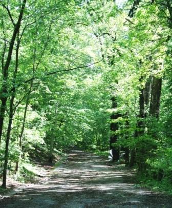
Endless delays
 Every level of government, other than the Council, has tacitly opposed the road, considering it too
expensive to build, too expensive to maintain, in too sensitive a location,
for too little traffic-flow benefit. I recall being told by a DDOT employee
that, whatever the Council did, the road would not be built, because the
agencies tasked to build the road would simply drag their feet and let the job
gather dust on some back shelf. I am certain that the National Park Service, for
one, disliked the road, preferring that the area revert to parkland, and
not become just another commuter route, and I predicted that the NPS would
prevent the construction of the road, even if no one else did. Meanwhile, the
road crumbled to ruins, under the nonstop attack of rainwater and
erosion.
Every level of government, other than the Council, has tacitly opposed the road, considering it too
expensive to build, too expensive to maintain, in too sensitive a location,
for too little traffic-flow benefit. I recall being told by a DDOT employee
that, whatever the Council did, the road would not be built, because the
agencies tasked to build the road would simply drag their feet and let the job
gather dust on some back shelf. I am certain that the National Park Service, for
one, disliked the road, preferring that the area revert to parkland, and
not become just another commuter route, and I predicted that the NPS would
prevent the construction of the road, even if no one else did. Meanwhile, the
road crumbled to ruins, under the nonstop attack of rainwater and
erosion.
In the event, it hasn't gotten as far as the Park Service. It
has been the Federal Highway Administration (FHwA) that has delayed the job for
months, stretching into years. The District's plan was to have the Federal
Government pay for 80% of the job, which in the beginning would have amounted to
$4M. An Environmental Impact Study was required for Federal funding of this
roadway through parkland, so the District set to work on that in 2003. The (first)
draft EIS was completed in mid-2005. The draft EIS was itself subject
to severe criticism, because it considered only the construction of the
road as an acceptable option, utterly rejecting the recreational and
natural-state options, on the grounds that they did not meet the legal
requirement specified in the District Council's 2003 act for a road "for motor
vehicle traffic". The DEIS considered only the one-way, one-lane, and two-way,
two-lane options. "Green Space" and "Bicycle, Recreation and Facility
Management", clearly the most environmentally sound options,�were discarded
without consideration.
It did come to this conclusion: "The
proposed project would be beneficial to residents and local commuters by
improving safety, and enhancing local circulation. Erosion throughout Klingle
Valley would be abated, which would have longterm beneficial impacts to local
vegetation, water quality, and aquatic organisms. To some, however, the
implementation of any of the build alternatives would not be beneficial. Opening
the road would diminish the park experience of those people who currently use
the area for jogging, bicycling, dog walking, and to enjoy quiet and solitude of
a closed Klingle Road. "
Indeed, none of the "build alternatives"
considered were thought acceptable to road opponents. But more significantly,
the FHwA found the DEIS unacceptable, and sent it back for revision, not once,
but repeatedly. Nothing the District did was quite satisfactory, and in January,
2008, more than four years after the EIS process was begun, the FHwA sent the
DEIS back to the District yet again, calling for extensive revisions.
A Councilmember reacts
 It isn't
hard to see these endless demands for revisions to the DEIS as a pattern of
intentional obstructionism. In March, 2008, Councilmember Graham, with support
from now-Mayor Fenty, attempted to have the District pay the entire cost of
rebuilding the road, forfeiting the 80% Federal contribution, but avoiding
the endless negotiations with the FHwA for the EIS. As had been done in
2003, this was attempted by means of a line item in the District budget act, not
as a self-standing Council act.
It isn't
hard to see these endless demands for revisions to the DEIS as a pattern of
intentional obstructionism. In March, 2008, Councilmember Graham, with support
from now-Mayor Fenty, attempted to have the District pay the entire cost of
rebuilding the road, forfeiting the 80% Federal contribution, but avoiding
the endless negotiations with the FHwA for the EIS. As had been done in
2003, this was attempted by means of a line item in the District budget act, not
as a self-standing Council act.
CM Graham made this attempt through a
line item in the Public Works budget, prepared by the Committee on Public Works
and the Environment, chaired by the Councilmember. That proposal did not get
far; if Klingle Road was controversial at a cost of $2M to the District, it was
a nonstarter at $11M. But this proposal in Graham's committee opened the door to
Ward 3 Councilmember Mary Cheh, also on that committee, to offer her line item
that a recreation trail be built instead of the road. At-large Councilmember
Kwame Brown is quoted as saying that "if Jim [Graham] had never moved this bill
through his committee, we wouldn't be having this conversation. He gave Council
Member [Mary] Cheh her opening."
CM Cheh
offered this text for the budget bill:
"(a) Of the funds authorized to be
spent in the fiscal year 2009 budget of the Department of Transportation, $2
million, from federal funds specifically identified as available to the District
to be spent in FY 2009 on Klingle Road, shall be allocated and used as
follows:
"(1) For the environmental remediation of Klingle Valley and
construction of a recreational trail, subject to the following
restrictions:
"(A) Existing pavement on Klingle Road, N.W., along the
portion between Porter Street, N.W., on the east to Cortland Place,N.W., on the
west, shall be removed;
"(B) Existing storm water and sewage pipes shall be
repaired, if necessary, to reduce or eliminate the runoff or discharge of storm
water or sewage water into Klingle Valley;
"(C) The recreational trail shall be constructed along the portion of Klingle Road, N.W., between Porter
Street, N.W. on the east to Cortland Place, N.W., on the west;
"(D)The right-of-way shall remain closed to motorized vehicular
traffic;
"(E) The recreational trail shall not exceed 10 feet in width;
and
"(F) The recreational trail shall be surfaced with a water-permeable
material."
Cheh's recreation-trail proposal was approved
in the committee by a three to two vote, Cheh, Brown, and Councilmember
Alexander voting for the trail, and against the road, over the votes of Graham
and Councilmember Bowser.
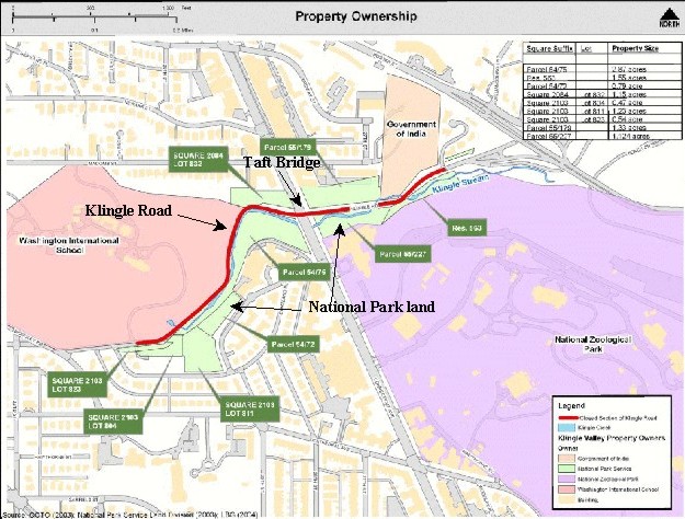
On May 8, 2008, CM Graham held a public roundtable on Klingle Road,
attempting to revive support for the road, versus the Cheh redirection to a
recreation trail. In fact, supporters of the bike/hike trail outnumbered
supporters of the automobile road at Graham's hearing. One surprise at this
hearing was the revelation that the building of the road would lead also to the
construction of five expensive houses along the currently-closed portion of
Klingle Road, completing the conversion of this wooded valley to residential
roadway. As the property ownership map shows, the north side of Klingle Road is
privately owned, by the Washington International School, and is thus susceptible
to development, directly across Klingle Road from national parkland. The best
summary of this development proposal will be found in this
2006 decision of the Mayor's Agent for Historic Preservation.
On May 13, the full Council undertook a first review of the Fiscal 2008
Budget. Graham took that opportunity to move that the Cheh amendment be deleted
from the budget bill. Astonishingly, he and Bowser could win the support of only
one other Councilmember, CM Schwartz. Graham's motion went down to a lopsided
defeat, 10 to 3. Even Councilmember David Catania, who had voted for the road in
2003, voted against it now, observing that this issue had consumed far too much
of their time and energy, and it was time to give it up.
Why the change?
One might ask what changed between 2003 and 2008, that the support for the
rebuilt road had so greatly changed. Perhaps it is simply exhaustion, as
Councilmembers (except perhaps CM Graham) are tired of spending so much
time and energy on such a small matter, while far more important city issues are
neglected. No doubt the Councilmembers from distant parts of the city resent the
spending of District funds for a road that will serve only a handful of
residents in one part of the city. Certainly the arrival of Councilmember Cheh
in Ward Three (in which the road lies), an unequivocal opponent of the road, has
made a difference. Perhaps also in the past five years people have become less
willing to surrender greenspace and parkland to automobilies. A minor note in
the disputation was a pair of unanimous votes by the Mount Pleasant ANC in
opposition to Klingle Road, first objecting to CM Graham's proposal for full
District funding of the road, then supporting CM Cheh's motion to replace the
road with a recreational trail. That would not have happened in 2003. I believe
everyone is becoming more sensitive to preservation of greenspace, and more
willing to support bicycles instead of cars for travel around the�District.
In 2003, the vote for the line item in the budget for
Klingle Road was 8 to 5. Five years later, the attempt by Councilmember Graham
to remove Cheh's item to replace the road with a bicycle-pedestrian path went
down to defeat, 10 to 3. Of those 10 votes against the road, only one was from a
Councilmember who had voted for the road in 2003 (Catania). The other votes
were from Councilmembers who were not on the Council in 2003. No doubt, like
Councilmember Barry, they object to spending so much money on a minor road in
Ward Three that would serve only a modest number of residents in Wards One and
Four, and which was strenuously opposed by the Councilmember for Ward
Three.
This combination of factors has led to these events in 2008,
culminating in the item in the budget bill overturning the item in 2003 that
called for restoration of the road.
The Klingle Valley Trail Environmental Assessment
The 2008 (FY2009)
budget bill took the road possibility off the table, allowing only the
construction of a "valley trail" for walking and bicycling, with vehicular
access limited to emergency and maintenance trucks. Instead of an Environmental
Impact Statement, the valley required only an Environmental Assessment, a
significantly easier accomplishment. The final draft of this Assessment was
released in December, 2010. The Klingle Valley Trail Environmental
Assessment recommendations are as follows:
"Following the public
comment period on the EA, DDOT identified the following as the preferred
alternative and preferred options. A complete description of each alternative
and option is provided in Section 2.2 of the Final EA. Responses to public and
agency comments are provided in Appendices A and B, respectively.
Alternative 2 - 10-Foot Multi-Use Trail (Permeable)
(Preferred Alternative)
"The preferred trail alternative is
Alternative 2, the 10-foot multi-use trail, which would be constructed using
permeable pavement or materials within the existing DDOT right-of-way. The trail
would include 2-foot shoulders on either side of the trail. The trail would
slope slightly to the opposite side of Klingle Creek toward a 2-foot wide,
1-foot deep flat bottom drainage swale. This drainage swale would include check
dams and capture runoff from the steep sideslopes on the north side of Klingle
Valley and slow stormwater flow.
Klingle Creek Restoration Option B (Preferred Option)
"The Klingle Creek Restoration Option B - Full Stream Channel and Bank Stabilization is the preferred option.
Under this option, DDOT will repair targeted channel and bank stability problems
throughout the project area, for a total of 1,595 linear feet of stream channel
restoration.
Access to Rock Creek Trail Option C-Modified (Preferred Option)
"DDOT decided on a combination of Option B - Shared-Use Connection and Option C - Multi-Use
Trail Connection, referred to as
Access to Rock Creek Trail Option C-Modified, as the preferred option to allow
access to Rock Creek Trails. This modified option would include a trailhead to
Klingle Valley. Under this option, a multi-use trail 6 to 8 feet in width would
be constructed along the south side of Klingle Road and continue along the ramp
before connecting with the Rock Creek Trail below Porter Street, NW. The
existing 20-foot wide vehicle travel lane will be redesigned to 12 to 14 feet
wide, and the trail would be separated from the existing vehicular travel lane
by a curb. The trail would be constructed within the existing footprint of the
existing roadway, and no new impervious surface would be added. Option
C-Modified would contribute approximately $1,216,228 to the total construction
cost for each Action Alternative.
Lighting Option B (Preferred Option)
"The preferred lighting option is Lighting Option B -
Pole or Bollard Lighting. Under Lighting Option B low impact pole lighting would
be incorporated into the proposed multi-use trail design. Low impact lighting
techniques, such as solar cells, which are powered by converting sunlight into
electricity, LEDs would be considered under this Option. The lighting of the
proposed multi-use trail would be timed to correspond with commuter use of the
facility to limit the hours of illumination.
"The total cost of the
Preferred Alternative and options will be approximately $6,763,823. The annual
cost of maintaining the trail will be approximately $5,840. The duration of
construction is anticipated to be 8 to 12 months."
The public review
period for this Environmental Assessment closes on February 15, 2011. Perhaps
the end to this controversy is in sight, 20 years after the road was closed due
to stormwater damage.
Return to home
Page created
May 15, 2008; modified February 13, 2011